Perception was kind enough to upload a case study of their work on Batman v Superman this week. That case study includes a map of the Metropolis-Gotham region as envisioned for the movies DC and WB have been making.
That map clearly does not hew to the maps of the two cities as published in the comics over the last couple of decades. Granted, the production team had the right to plant the two super-cities ten miles and a harbour apart from each other. Speaking for myself alone, I'd hoped that Byrne's Six Boroughs as originally drawn up for Metropolis in 1986, as well as the islands of Eliot Brown's 2000 map of Gotham could've made the cut.
Oh well...this is its own thing to begin with.
DC CinemaVerse Geography: Metro-Gotham
Jul. 11th, 2015 06:03 pmNot the first time it's been done. The newspaper comics of the 1970's did it. So we know where Zack Snyder's getting some of his inspiration.
I just wish they'd stick with Eliot Brown's map in toto for Gotham, like they decided to stick with John Byrne's Six Boroughs for Metropolis in Man of Steel. As it is, we've seen from photos taken at location shoot sites that they cribbed the location names from that map, and are using a modified map of Detroit for Gotham to plant those names on.
http://whatculture.com/film/batman-v...fan-see.php/19
https://twitter.com/tribluis/status/532676691752386560
What do you see in those visuals?
Evidence herein, from location shooting for Man of Steel:
http://www.supermanhomepage.com/images/man-of-steel-movie2/110914-taxi1.html
At least the motto fits.
Looking back at this entry on Pete Woods' mapping out of Metropolis for the purposes of Geoff Johns, James Robinson and company a couple of years back...particularly in the context of this YouTube video Pete uploaded for other artists to work from.
The whole thing still seems a bit inconsistent with what was previously established, but I must give kudos to the effort that Pete put into this project. This took a lot of work to nail down as much as he did.
Comic Book Movie Maps: A Pointed Query
Jul. 30th, 2012 05:06 pm- Matt Hatton
- Beth Garswood
- graphic design
- Superman Returns
Are they still working in the field?
http://dewline.livejournal.com/333415.html
I need to do the same.
( Read more... )
That's the population of Metropolis during the Legion's first year, according to Brainiac 5. "78 million sentient inhabitants in the urban zone before you reach the greenbelt" being the exact phrasing as recorded in Adventure # 515.
It's been three or four months since that issue saw print, but that figure has started to nag at me a little. So, I did a little digging. I'll do it again here, just to make sure that the "show your work" crowd is working from the same playbook.
Here's a map of 30th Century Metropolis as sanctioned by Legion writer past and present Paul Levitz, and modified for re-use back in Who's Who in the LSH # 6, circa 1988:

Using 2009 estimates from the US census people as provided by Wikipedia...
Connecticut: 3,518,288
Rhode Island: 1,053,209
Massachussetts: 6,593,587
New York and New Jersey get a little tricky here, seeing as not all of each of those two states gets incorporated into the boundaries of Legion Era Metropolis...so we're going to put that off to "Step Two", which may involve a little Google Earth, a little Photoshop...
Metropolis from 1986 to 2009
Sep. 2nd, 2009 08:49 pm( Read more... )
Metropolis Changes
Aug. 21st, 2009 09:43 pmTurns out that I was a little off on my expectations.
( Read more... )
Metropolis As Once Was Mapped
Dec. 20th, 2008 08:29 pmThis is the map I was telling

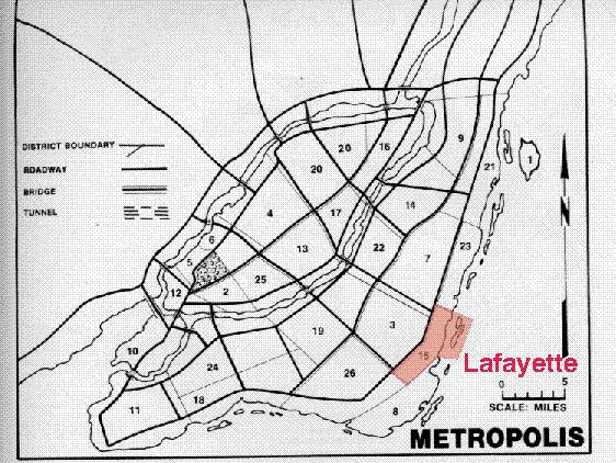
I've specifically highlighted the neighbourhood I spoke of in that earlier posting, Lafayette, which according to the authors of the original DC Heroes Gamemaster's Manual of 1985, was home to an Acadien-originated settlement. In fact, it was described as having a largely Francophone community to that date.
Granted, the city's since been through some changes beginning with the renovations of Byrne, Wolfman and Helfer begun over phone calls and business correspondence probably that very year and put into action the following year with Man of Steel. Kurt Busiek put some of the neighbourhoods from that earlier Mayfair-designed map back into the modern Six Boroughs during his tenure on Action and Superman, though...so why not Lafayette as well?
And yes, there is a certain resemblance to Montréal in that older map, isn't there?
Urban Sprawl in Comics Redux?
Jul. 8th, 2006 08:22 amQuestion: how chilling(or not) do you find the implications of a single city running all the way from Cape Breton to Key West?
Yours, whilst still wishing I'd gotten that Daily Planet Guide to the Legion Worlds project with West End Games past the outline stage,
Dwight